Issued (11 UTC) 7pm PhT 071713
___________________________
Video Update:
Tropical Storm Cimaron (Bagyong Isang) is now moving across Luzon Strait after making landfall in Cagayan earlier today. The storm was last located approximately 70km southwest of Basco, Batanes or about 220km north northeast of Laoag, Ilocos Norte. Maximum sustained winds are at 65kph with gusts of up to 85kph. TS Cimaron is moving northwestward at 25kph.
As of 5pm this afternoon, PAGASA has raised Public Storm Warning Signal #1 for Ilocos Norte, Calayan, Batanes, and Babuyan Group of Islands. Other Signal #1 Warnings have been dropped.
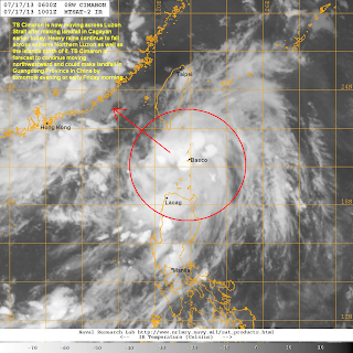
IR Image from NRLMRY
Latest satellite image shows Cimaron moving near the Batanes Group of Islands. Convection and overall organization has slightly improved prompting both JTWC and JMA to upgrade the system to a Tropical Storm. Heavy rains continue to fall across Batanes and nearby islands as well as in Extreme Northern Luzon. As much as 100mm of rain has been recorded in the region since yesterday. Farther to the south, scattered rain showers have also caused problems including in Metro Manila.
Forecast Track (NOT OFFICIAL!)
Tropical Storm Cimaron will continue moving northwestward and could make landfall in Guangdong Province in Southeastern China by tomorrow evening (Thursday) or early Friday morning. It still has time to slightly intensify tonight and into tomorrow but we are not really expecting any significant intensification. Cimaron should also affect Southern Taiwan, bringing scattered rains across Southern Taiwan. Then as it makes landfall, the threat of heavy rain will shift to Guangdong and nearby provinces in China.
We'll have another update tomorrow morning.


No comments:
Post a Comment