_________________________________
Here is our latest video update on TS Sonamu/Auring. Scroll down below for our complete Text Update.
*********************************
Text Update
Tropical Storm Sonamu (Bagyong Auring) is now leaving the Philippine Area of Responsibility. The storm was last located approximately 510km southwest of Puerto Princesa City or about 900km east southeast of Ho Chi Minh in Southern Vietnam. Maximum sustained winds are at 65kph with gusts of up to 85kph. TS Sonamu is moving westward at 20kph.
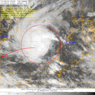
IR Image from NRLMRY
Latest satellite image shows an improvement with regard to Sonamu's overall structure. While there is still moderate wind shear, the convection appears more organized with cold cloud tops emanating from the center. Fortunately, the bulk of the rain clouds are now over the South China Sea (West Philippine Sea) and are no longer affecting the Philippines.
2-Day Rainfall Reports (NOT OFFICIAL!)
In terms of the rainfall impact, heavy rains were reported across Northern Mindanao, Central and Eastern Visayas, and Southern Palawan due to the passage of Sonamu/Auring. It caused disruptions in sea and air travel as well as minor flooding in some cities. As we head into the weekend, much of the Philippines should expect somewhat better weather except in the eastern portions of the country. The Inter-Tropical Convergence Zone and the Northeast Monsoon (Amihan) will continue to bring light to moderate rains in these areas. We are also watching the possibility of yet another cyclone forming by late next week; right now, the chances are still low but the possibility remains.
For the latest radar images and rainfall forecasts for areas in the Philippines, click HERE (ClimateX PH)
Forecast Track (NOT OFFICIAL!)
Tropical Storm Sonamu will continue moving westward across the South China Sea; perhaps intensifying a little over the weekend. It is not expected to make landfall in Vietnam but could get close enough to bring light to moderate rains in the southern tip of the country including Ho Chi Minh. By Monday and Tuesday, the system is forecast to curve southwestward into the Malay Peninsula; but by that time, Sonamu should start weakening to a Tropical Depression.
We'll have another update tomorrow.


No comments:
Post a Comment