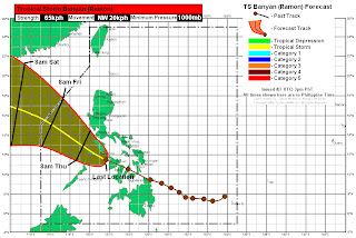
As of 5pm today, PAGASA has raised Signal #2 for Marinduque, Mindoro Provinces, Romblon, Southern Quezon, Burias Island, Northern Palawan, Calamian Group of Islands, Cavite, Laguna, Batangas, Metro Manila, Panay Island, and Guimaras Island.
Most areas in Visayas and Northern Mindanao have already received 100 to 200mm or rain this past 24 hours. We are still expecting around 100mm to fall across Western Visayas and Southern Luzon tonight. Weather across Central and Eastern Visayas should begin to improve tonight and tomorrow. Southern Luzon, including Manila, will receive light to moderate rains with breezy conditions starting tonight and into tomorrow morning.
Banyan is forecast to continue moving west northwestward, maintaining weak tropical storm strength. It should be moving out of the Philippines by Thursday afternoon and could be completely out of the Philippine Area of Responsibility by Friday morning. It could intensify as it moves across the South China Sea due to weaker wind shear (Saturday). Based on JTWC's long range forecast, Banyan could hit Vietnam by early next week.
Personal Forecast (NOT OFFICIAL)
We'll have another update tomorrow.
_______________________________________
Issued (10 UTC) 6pm PhT 101211

No comments:
Post a Comment