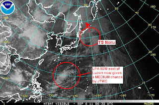
Tropical Storm Noru won't really be a threat to Japan anymore. Computer models and weather agencies are in pretty good agreement as to the system's evolution over the next two days. It is forecast to continue moving northward, approaching the Kuril Islands tomorrow. It will then move across the Sea of Okhotsk as an extra-tropical cyclone. It could also interact with a LOW near Russia (remnants of Talas).
As for the rest of the Pacific, we are still watching Invest 90W which is showing signs of improvement over the past 24 hours. It was last located more than 900km away (east) from Luzon. ASCAT still shows a closed circulation and the IR presentation is also improving with convective activity in and around the center. Wind shear is low at around 10kts and sea surface temperatures are fairly warm here in the Philippine Sea. JTWC has upgraded 90W's chances to "MEDIUM". It is still uncertain, however, whether 90W will affect the Philippines so please stay tuned here.
This is our video update regarding Tropical Storm Noru, Invest 90W, and Hurricane Katia in the Atlantic.
Issued (0830 UTC) 430pm PhT 090611

No comments:
Post a Comment